Canada Water Campaign Canada
Water Campaign Home
|
 |
Canada Water Campaign Canada
Water Campaign Home
|
|
- Fifth Draft – April 2002
1. Introduction
2. Development context
2.1 General location
2.2 Site ownership and tenure
2.3 land use
2.4 History
2.5 Consultation
2.6 Demographics
2.7 Local issues
2.8 Topic papers
3. Planning
3.1 National planning policy and guidance
3.2 Regional planning guidance
3.3 Borough planning policies
4. Transport
5. Context appraisal
5.1 Land utilisation
5.2 Character and quality of the public realm
5.3 Local aspirations
5.4 Local ecology and wildlife
5.5 Infrastructure and services
5.6 Engineering constraints
5.7 SWOT Analysis
5.8 Opportunities for new connecting routes
6. Urban Design Principles
6.1 Design Objectives
6.2 Urban structure
6.3 Urban grain
6.4 Density and mix of uses
6.5 Scale, height and massing
6.6 Buildings
6.7 Public Spaces
6.8 Landscape and ecology
6.9 Public art and cultural regeneration
6.10 Parking and servicing
7.0 Management
8.0 Bibliography and Glossary
9.0. Appendices
Additional copies of the Planning and Design Principles, Technical Appendices and the Development Offer can be downloaded from the Canada Water web site:
1.0 Introduction
The challenge is to create high quality development that meets government policy and sustainability agenda whilst at the same time engaging with the local community in achieving its aspirations.
The Planning and Design Principles contained in this document identify the key issues to be addressed by masterplan proposals and provides detailed technical background as appendices. Together with the Development Offer, it forms the Development Brief for the second wave of regeneration at Canada Water. This document has been prepared for Southwark Council and includes sections drafted in consultation with representatives of the local community.
Second Wave Regeneration
The existence of a sizeable area of brownfield land astride an important transport interchange represents a rare opportunity create a mixed-use development which will, for the first time, provide a vibrant focus for the Rotherhithe Peninsula.
Development proposals for the area need to respond to local aspirations and set a bench mark for the redevelopment of other sites in proximity to major public transport infrastructure.
The Canada Water dock basin, which lies at the centre of the area, is to be retained in any development and maintained as a wildlife habitat (see also Section 6.3).
1.1 Development objectives
New development must address the shortcomings of earlier patterns of retail development in the core area and build on the many environmental assets of the area. New development must preserve the character of the Rotherhithe Peninsula and build from its many environmental qualities. Development of the core area will have an impact on the entire Peninsula and therefore should be used as an opportunity to improve the quality of life for the whole community.
Canada Water Underground Station lies at the centre of a circle of development within easy walking distance of the public transport facilities and bounded by an outer ring of parks and woodland. The area therefore offers the possibility of a compact nucleus of development at its centre with an extensive outer belt of recreational amenities and natural environment within easy reach.
The main aim is therefore to make Canada Water and its interchange the heart of the community, with a mixed-use development in an attractive, waterfront setting.
The other objectives this Brief addresses are:
• Identifying an appropriate scale and mix of development;
• Identifying opportunities to enhance connections between the Canada Water basin and the surrounding area and with Rotherhithe and Surrey Quays Underground stations; and
• Relate to sites in multiple ownership as the basis for a coherent, phased development plan.
If Canada Water is to provide a new community focus for the Rotherhithe Peninsula, it needs to be distinctive, recognisable, economically lively, broad-based in appeal, well linked to the surrounding community and imaginative in design. Development must take this opportunity to create the real streets, and public spaces that characterise other successful mixed-use centres whilst recognising the unique qualities that distinguish this area.
Public spaces of the highest quality and distinctive architecture should replace the monotony of boxy sheds and blocks of flats that currently characterise the area.
The local community’s vision for the area as expressed by the Canada Water Campaign looks to achieve:
The challenge is then to create high quality development that meets government policy and the sustainability agenda and realises land value whilst at the same time engages with the local community and their aspirations.
The community, through the Canada Water Consultative Forum are well aware and support the need for all aspects of this challenge to be met.
1.2 Sustainability
This Development Brief is predicated on the requirement for the delivery of a sustainable form of development for Canada Water. The principles of sustainable development therefore underpin all sections of this Brief and proposals for the Canada Water sites must demonstrate in detail how they will contribute to achieving these objectives.
In particular, development must make full use of the unique potential offered by the Canada Water sites through appropriate land use that sympathetically uses scarce and finite land resources and that by means of integrated transport strategies and mixed land use minimises reliance on private car journeys.
The term ‘sustainability’ is used to denote the objective of achieving patterns of human activity which can be permanently sustained by future generations without compromising either social cohesion or global resources.
The pattern of development in towns and cities has a significant impact on both the environment and the opportunities to build communities that are socially and economically sustainable
Government policy reflects an increasing desire to develop models of sustainable development which in their ideal form might:
“Good design brings very specific economic, social and environmental benefits to a range of stakeholders... good design can be shown to bring a variety of benefits, including less crime, a more vibrant public realm, more efficient movement and improved health. All this means less social exclusion and cash savings for the public purse”. Sir Stuart Lipton, Chairman CABE
2.0 Development Context
2.1 General location
The sites lie at a strategic location centred on Canada Water Underground Station and the nearby dock. The sites offer the potential for establishing linking routes both to the hinterland to the north and west (including the Canada Water Estate), and to the Canada Water basin itself.
The sites are exceptionally well served by public transport. The Canada Water Station provides interchange between the Jubilee Line, East London Line and bus services. In addition, Rotherhithe and Surrey Quays stations are within walking distance. Canada Water Station and adjacent sites occupy a strategic position at the heart of Rotherhithe.
2.2 Site ownership
Key land parcels form a wider area of significant redevelopment potential comprising several large sites. These are identified on the Location Plan (left –not included) and table below.
In addition to these sites, future development potential is likely to be opened up as part of the planned East London line extension works including possibly the redevelopment of Rotherhithe and Surrey Quays stations.
| Site | Ownership | Land use | Approx. area |
| A | Southwark Council | Open brownfield* | 2.5Ha |
| B | Southwark Council | Open brownfield* | 0.8Ha |
| C | Foreign Property ApS | A1 Retail | 1.9Ha |
| D | Ampurius Holdings | D2 Leisure** | 0.6Ha |
| E | Foreign Property ApS | A1 Retail | 0.8Ha |
| F | Shopping Centres Ltd† | Car park for G | 0.5Ha |
| G | Shopping Centres Ltd† | A1/A3 Retail & car park | 8.1Ha |
*see UDP summary
**with permission for residential/mixed use
† Under L.B. Southwark freehold
Land ownership shown is correct at time of publication.
2.3 Land Use
The table above indicates the current uses of the Canada Water sites. The Land Use Plan (left – not included) indicates the broad areas of land use for the surrounding area. Land use is zoned into single land uses with only limited and localised areas of mixed use development notably along Lower Road where it forms a local high street, Albion Road with its parade of shops and community buildings, and the more historic, riverside areas of Rotherhithe.
2.4 History
The village of Rotherhithe was associated with shipbuilding from as early as the 14th century. The peninsula comprised wet marshland and was therefore a good location for docks, the first of which was constructed in 1696.
The docks, which were named after the trading nations whose goods arrived in Rotherhithe, continued to thrive into the 20th century but the introduction of container transportation led to the closure of the docks in 1969.
Between 1981 and 1996 the peninsula underwent a significant transformation overseen by the LDDC. Development has been largely residential with a variety of tenures. In addition, 840,000 ft.2 of commercial accommodation was completed on the peninsula. One element of this was the Surrey Quays Shopping centre which opened in 1988.
A brief history of the area is given in Appendix 13.
Morphology
Whilst the street pattern, block form and many of the industrial buildings have survived intact along the riverside to the north of Canada Water, the built form of much of the Rotherhithe Peninsula today shows few traces of its historic development. The extensive network of docks and canals was comprehensively redeveloped during the 1980’s. New roads ignored the historic street pattern: Salter Road bypassed Rotherhithe Street and Surrey Quays Road and its associated industrial and retail development cuts across the historic pattern of land and water.
2.5 Extent of consultation informing the design process
Extensive consultation has been carried out as part of the process to define a Development Brief for the area including the following:
Canada Water Urban Study
The Canada Water Urban Study undertaken by the London School of Economics (LSE) in July 1999 carried out a survey of social and economic factors based on limited public consultation.
It suggested that new housing on the site should be considered only in concert with a series of other uses, such as retail or local facilities. Housing over retail shops, for example, would be more appropriate to creating a more socially balanced development, than additional ‘dormitory’ type development.
Thus, housing should be an ancillary, not a primary use, for the site.The full text of the LSE Study is included in Appendix 5.
MORI POLL
A MORI poll was conducted during 2001 to establish local attitudes towards development and community needs. A key determinant was that residents in the Rotherhithe Peninsula liked the low rise, semi suburban character of the area, being relatively low density, well provided with parks and open space although the need for better facilities at Canada Water itself was quite apparent. SEE SUMMARY OF THE MORI FINDINGS IN APPENDIX…..
Canada Water Campaign
The Canada Water Campaign (CWC) is a community pressure group established in July 2000 to express community aspirations for the development of the area. The CWC’s vision for the area is provided in Appendix 6 and stated in para 1.1 above.
Canada Water Consultative Forum
The Forum was established in April 2001 to establish dialogue between local community groups including the Canada Water Campaign, representatives of other community groups, local councillors and Southwark officers. The Forum holds frequent meetings and will provide the basis for ongoing consultation with Southwark Council and their development partners.
CTRU
In October and November 2001, the Civic Trust Regeneration Unit (CTRU) carried out a series of workshops with local community groups. The full text of the CTRU report is included in Appendix 8.
2.6 Demographics
The resident population of the Rotherhithe peninsula is approximately 18,500 of which 54% are in social groups ABC1 – above the national average. However, this social distribution is not reflected in the distribution of shoppers at the Surrey Quays Shopping Centre (SQSC). Research suggests that many residents continue to travel out of Surrey Quays to shop.
It should be noted that the general influx of more affluent residents across the area from Waterloo to Greenwich requires that we consider Canada Water as having a mixed population with a spending power equivalent to at least the London average but that lack of local provision is resulting in much of this spending draining to other areas. Further, particular opportunities exist to not merely halt the exodus of spending power from the area but to attract new spending from outside the area.
The key economic issues include:
2.7 Local issues
Through public consultation carried out by the Civic Trust Regeneration Unit, the following issues have been identified:
Of these, maintenance, community safety and community involvement were identified as important issues.
2.8 Topic papers
A series of topic papers have been prepared by the Canada Water Consultative Forum, based on advice from the relevant departments at Southwark Council and contributions from the local community. These papers cover:
The Topic Papers set out in more detail the important local issues that must be addressed by development proposls.
The full text of these Topic Papers is included in Appendix 11. These papers will continue to evolve in consultation with the community during the course of the project.
3.0 Planning Context
“Much of London’s appeal as a world city is due to the attractive character of its residential areas. The London Plan will seek to protect and enhance those features, which are valued by local communities. Among these are safety and security, privacy, amenity and open space.”
3.1 National planning policy and guidance
Canada Water exemplifies the urban brownfield site close to excellent public transport services that the government must have had in mind in setting their policy as stated in Planning Policy Guidance Notes 1, 3 and 13 (see also Section 4.0: Transport and the transport topic paper)
Development sites should accommodate a mix of uses rather than a single use as set out in PPG1 General Policy and Principles (1997).
PPG13 Transport (2001) clearly advocates the need to integrate land use and transportation planning. It highlights the importance of ‘key sites’ that are either in town centres or are close to transport interchanges. Sites which are highly accessible by public transport, should be developed for travel intensive uses (including offices, retail, commercial leisure, hospitals and conference facilities), ensuring efficient use of land.
The need for higher residential densities is emphasised in PPG3 Housing (DTLR 2000) which states that residential developments of less than 30 dwellings per hectare should be avoided and densities above 50 dwellings per hectare should be encouraged at locations with good access to public transport.
Canada Water will need a sensitive approach designed to protect the unique character of the Rotherhithe Peninsula. The Government’s Urban White Paper states that its planning policies “do not mean cramming people closer and closer together. It means development at reasonable densities which protect open spaces and respect the need for privacy” The White Paper also recognises that what may be appropriate for one area may be completely inappropriate for another.
3.2 Regional planning guidance – The London Development Agency and GLA London Plan
The recent consultation document for London’s Spatial Development Strategy ‘Towards the London Plan’ (GLA 2001) seeks to encourage sustainable growth in London. There is a particular emphasis in the document on the need to integrate development decisions and existing and proposed public transport capacity.
RPG 3 seeks to control the height of developments within the viewing corridor protecting the strategic view of St. Paul’s Cathedral from Greenwich and the viewing corridors protecting the Strategic View of St. Paul’s Cathedral from Blackheath Point, Richmond Park and Westminster Pier.
3.3 Borough planning policies
The Southwark Unitary Development Plan was adopted in 1995 and is currently under review. The Canada Water area is designated as one of several Regeneration Areas within the Borough. The Council is seeking to stimulate and direct private investment in partnership with the public sector to targeted areas, to assist the local economy, improve the environment and meet community need.
Current policies support proposals which:
Within the current policy framework, proposals might include business, entertainment, housing, shops, ancillary open spaces and community facilities.
New developments should normally be of an appropriate height to:
Bermondsey and Rotherhithe Local Issues Paper
As part of the process of reviewing and updating the UDP, the Council has prepared a number of local issues papers. One of these (LIP2) covers the Bermondsey and Rotherhithe area and states that:
‘The LDDC created an area that is very suburban in character and does not take advantage of the special setting on the river close to Central London and tends to encourage the use of cars. Further development of the area must reflect its accessibility and be geared towards a people friendly environment.’
Detailed summaries of Planning Policy context are included in Appendices 1.
New development at Canada Water must meet planning requirements at national, regional, borough and local levels:
| National | Regional | Borough | Local |
| Densities above 50 dwellings/Ha | Efficient use of land | Generate employment | Community focus |
| Mixed use | Reduced reliance on cars | Improve the environment | Public spaces |
| Suitable for travel-intensive use | Safeguard strategic views | Bring vacant land into use | Community facilities |
| Housing tenure and affordability | Traffic and transport | Public safety | |
| Congestion | |||
| Environmental quality |
4.0 Transport
Harnessing the transport potential at Canada Water, through developing and implementing a comprehensive and co-ordinated transport strategy, will be key to ensuring the area’s transition from a place that happens to be located close to important transport infrastructure to a vibrant, accessible, sustainable, mixed-use urban centre.
4.1 Background
The study area is served by two London Underground lines: the Jubilee Line at Canada Water station; and the East London Line at Canada Water and also at Surrey Quays station to the south and Rotherhithe station to the north. It is also served by eight bus routes that provide links to the south and west and directly north via the Rotherhithe Tunnel.
4.2 Highway network
The study area is bounded to the west and south by district distributor roads – the A200 Lower Road and A2202 Redriff Road - and to the north and east by Surrey Quays Road, a local distributor.
Rotherhithe has the highest density of cycle lanes in the borough, with notable routes including Rotherhithe Street, the Albion Channel, the ecological park and Russia Dock Woodland, and Greenland Dock.
These networks make the Canada Water area highly accessible. However, local conditions currently prevent this full potential from being achieved. Specific issues include:
The development of Canada Water must seek to address these shortcomings, and release the full potential of the transport networks, through the identification and implementation of a co-ordinated transport strategy.
Recent public consultation has drawn attention to the following perceptions and ideas relating to transport in the study area:
Other transport-related issues should also be taken into account in planning development at Canada Water. These include:
A detailed transport assessment is included as Appendix 12.
The community’s Transport topic paper is included in appendix 11.
5.0 Context Appraisal
5.1 Land utilisation
The pie chart represents an analysis of an area within 750m (about half a mile) of Canada Water Station, it demonstrates that the area is well provided with open space – fully one third of the land area is public open space or water. The diagram also shows that cars take up a disproportionately large share of the land – more than a quarter of the land area is given over to roads and car parking (although this is still less than the average across Southwark).
5.2 Character and quality of the public realm
The unique aspect of the Rotherhithe Peninsula is characterised by a generally suburban development form consisting of mainly low and medium-rise housing estates and light industry.
This gives residents a feel of tranquillity when set against the intense business activity of the City of London and Canary Wharf both of which are close. The immediate environs of Canada Water itself are dominated by the Surrey Quays Shopping Centre and retail warehousing sheds, all surrounded by large expanses of car parking and service yards.
The area has many qualities that are valued by the local community, the foremost of which is the extensive areas of green spaces including Southwark Park, Russia Dock Woodland and Stave Hill nature park, as well as areas of open water including Lavender Pond, Surrey Water, Canada Water and Greenland Dock. Some of these areas are classified as Sites of Borough Importance by the London Ecology Unit (see Appendix 15). This network of spaces provide not only valuable wildlife habitat but also attractive leisure amenity and educational resources including the Pump House centre at Lavender Pond and the Surrey Docks Farm.
The Canada Water dock basin was arbitrarily truncated by the LDDC redevelopment with crude sheet piling forming one edge and its historic connection to Greenland Dock was lost.
Despite this, Canada Water has significant symbolic importance for the identity of the area and the local community. It is important, therefore, that proposals for the area include specific measures for mitigating the environmental impacts of development and enhancing the dock to create a fitting centre-piece for the area.
The Canada Water basin and Albion Channel provide attractive areas for walking and limited leisure activity. The wider area is well provided for by public open space. Southwark Park, Greenland Dock and Russia Dock Woodland are all within easy walking distance. A smaller park, King George’s Field is situated at the junction of Lower Road and Surrey Quays Road.
Key Characteristics of the area can be summarised as:
Quality of the public realm
Key aspects of the public realm are:
Local roads and footpaths are afforded minimal passive surveillance due to the pattern of development, notably:
Access to public transport
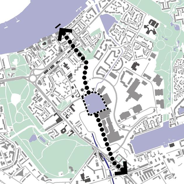
The Isochrome diagram illustrates areas within an equal walking time of Canada Water Underground Station. Access to Canada Water bus and tube stations is compromised by poor pedestrian linkages with circuitous routes especially from Albion Street, the Canada Water Estate and from Lower Road. The wall created by the back of the bus garage particularly disadvantages residents of the Canada Water Estate.
Ease of movement and access
The areas to the north, west and east of the sites are at present poorly connected to the tube station in terms of pedestrian or vehicular routes. The Canada Water Estate immediately to the west of the site is separated from the bus and tube interchange by the wall of the bus garage which turns its back on the estate. The former Pump House and the neighbouring 1930’s housing estate form a barrier to movement from the north and connections to Rotherhithe Underground Station and the Thames.
The Albion Channel provides an attractive pedestrian route to the north-east and Needleman Street provides vehicular access to the housing developments to the west. However, these connections are not well integrated into the wider street pattern. The combination of this factor together with the extensive area of the Russia Dock Woodland result in an band of low movement permeability to the north and west of the sites.
Lower Road constitutes the main movement spine to the west of the sites but there is little reason for pedestrians to cross this road other than to visit Southwark Park with the result that heavy traffic en route to the Rotherhithe Tunnel, coupled with weak pedestrian connections to the west conspire to make Lower Road a significant barrier severing Canada Water from areas to the west.
Legibility
Overall, the area lacks a legible centre. The location of the Canada Water bus and tube stations is disorientating for passengers emerging into an open expanse of undeveloped land, separated from major through-routes. This poor sense of legibility is exacerbated by the serpentine arrangement of Surrey Quays Road. From Canada Water Station, there is no physical clue to the direction of Surrey Quays Station to the south. Any indication of a route through is lost in a sea of car parking.
The two 1960’s tower housing blocks (Canada Water Estate) and the Pump House chimney provide local landmarks marking the location of Canada Water Station from Surrey Quays or Lower Road. The locations of these and other local landmarks and public buildings are identified on the plan left.
Diversity
The Rotherhithe area is predominantly residential with minimal mixed-use development. Choice in shopping and leisure activities is limited. Overall, there is a lack of diversity that belies the varied communities living in the area.
5.4 Local ecology and wildlife
The dock basin
The Canada Water dock basin provides an important local amenity both as a public open space and for leisure activities including angling and ornithology. The dock basin includes a wildlife sanctuary which is likely to be affected by any nearby development. The site is, located between two extensive areas of park and natural habitat: Southwark Park and Russia Dock Woodland and form part of an extensive network of open spaces and wildlife habitat.
The major issues for nature conservation at Canada Water are shading, ‘confinement’, altered microclimate, loss of critical habitat area, and disturbance. It is important to ensure that the existing arrangement of Canada Water is enhanced and that the significant planned changes to its environs will not alter the value to wildlife. Built form affects shading, microclimate and the physical connectivity to other wildlife areas, creating a sense of enclosure. The resulting outdoor microclimate is as important to people as it is to wildlife and will have a bearing on the use of space by both.
Ecological overview
Local ecology must be considered as part of a network of wildlife habitats where the critical size for sustainable habitat and biodiversity are important issues.
Canada Water is an area of Conservation Importance, feeding into a metropolitan network supporting urban wildlife resources.
Habitats need to be of a critical size to sustain wildlife populations as well as to be linked, either directly or by proximity, to a greater metropolitan wildlife habitat network. If metropolitan nature conservation is viewed holistically as a network, clearly any loss of a significant component in that network will impact upon other areas of nature conservation value.
Many of the expanses of water and wetland in the vicinity are designated of Nature Conservation Importance by the former London Ecology Unit (now incorporated into the GLA Biodiversity Group Strategy Directorate). Designated sites are graded as being of Local, Borough (grade I and II), and Metropolitan Importance.
All development proposals are required to demonstrate how the effects on wildlife will be mitigated during construction and use. Development will be required to demonstrate that there will be environmental improvements to support the wildlife and no long-term detrimental impacts on Canada Water and the wildlife that depend on it.
Full text of the report ‘Canada Water: an Overview of Ecological Issues’ by Studio Engleback is included in Appendix 15. The community topic paper on Green spaces is included in Appendix 11.
5.5 Infrastructure and services
The key Infrastructure constraints on the site are:
5.6 Engineering constraints
The main engineering constraints on the site relate to its close proximity to the River Thames and from two key chapters in the historical development of the site, namely the docks and underground railways.
Geologically the site is low lying and sits on a flood plain. Although there is flood protection guarding against regular flooding, the whole peninsula is still liable to flooding based on 1-in-100 year flood levels published by the Environmental Agency. The ground conditions near the surface are also quite poor, generally comprising alluvial deposits underlying fill. Pockets of peat lie within these alluvial deposits and the water table is slightly variable.
A significant constraint is a step in level of about 3m that occurs along the western edge of the site. This formed the boundary of the old Surrey Commercial Docks and is linked with excavated spoil from building the docks. The step also coincides with where the East London Line comes to the surface in a cutting, north of Surrey Quays, and together they form an impermeable barrier along this side of the site.
Canada Water basin forms the remnant of Canada Dock, which was up to 27 feet deep. Other docks also covered the site. Following closure of the Surrey Docks, the docks were back-filled providing added complexities with ground conditions near the surface. Old dock walls probably remain forming significant obstacles in the ground.
The East London Line and Jubilee Line Extension both run under the site, crossing one another at Canada Water station. Both railway lines and the underground station form significant constraints to any future development of the site, placing limitations on what can be built over or beside these structures. These constraints extend to above ground structures such as the triangular escape shaft on the Jubilee Line Extension and the brick air shafts above the East London Line tunnel.
The previous presence of a White Lead, Sulphur and Saltpetre works on the site and the amount of back-filling following the docks closure also raises the potential issue of contamination. This needs exploring in more detail.
The main infrastructure runs along Lower Road, Redriff Road, Surrey Quays Road and Needham Street, although there is also a main gas main running across the derelict ground at the northern end of site.
Detailed summaries of Engineering and infrastructural constraints are included in Appendix 2.
Constraints summary
Key constraints on development include:
5.7 SWOT (strengths, weaknesses, opportunities and threats) analysis
The table right, summarises the principal strengths, weaknesses, opportunities and threats facing the regeneration of the Canada Water area.
Challenges
The opportunities identified in the table are translated into the following key elements required for masterplan proposals:
In addition, the following opportunities will be considered to add value to proposals for the area’s development:
| Strengths | Weaknesses | Opportunities | Threats |
| Excellent transport connections | Lower Road access to Rotherhithe Tunnel | Better connected pattern of routes and spaces | Piecemeal or uncoordinated redevelopment |
| Close proximity to City and West End | poor legibility | Improved pedestrian and cycle routes | failure to reconcile community objectives with commercial imperatives |
| Waterside location | Intimidating and poorly connected pedestrian routes | Creating attractive waterside public spaces | Inefficient or wasteful land use |
| Close proximity to public open space amenity | Fragmented development form | Potential views from buildings | |
| Active and vocal local community | Car-dominated environment | Release of car park sites through safe, structured parking provision | Increased traffic congestion |
| Well endowed with green spaces and wildlife habitat | Shopping and community facilities | New public buildings and space | Overloading of JLE and East London line links due to un co-ordinated parallel development in Tower Hamlets, Canary Wharf and in Greenwich |
| Segregated building uses | New landmark architecture | ||
| Fragmented community
|
New green links connecting existing open spaces and water |
5.8 Opportunities for new connecting routes
New development should exploit as many opportunities as are feasible to connect into the existing street network.
Potential connections into Renforth Street and Lower Road are illustrated below. Achieving these connections will be subject to technical constraints and consultation.
Connection Options from Renforth Street
The plans and associated photographs illustrate potential routes for new movement linkages for vehicles and/or pedestrians that might be investigated further.
Connection Options from Lower Road
The plans and associated photographs illustrate potential routes for new movement linkages for vehicles and/or pedestrians that might be investigated further.
6.0 Urban Design Principles
All places need a vision of what they want to be: whether they wish to resist or respond to change, compete with other places, or preserve their unique qualities.
6.1 Design Objectives
The planning and design principles set out below avoid prescriptive solutions but identify the essential urban design principles that should guide new development.
Design Objectives include:
In addition to these specific requirements, ‘By Design’ published by CABE/DETR sets out the qualities that define good urban design. These have been included in a list of eight principles, highlighted below, that should inform all aspects of the development proposals.
| 1 Character: A place with its own identity | Promote character by responding to locally distinctive patterns of development and culture. |
| 2 Continuity and enclosure: A place where public and private space are clearly distinguished | Promote the continuity of street frontages and the enclosure of space by development which clearly defines private and public areas. |
| 3 Quality of the public realm: A place with a good quality public realm | To promote public spaces and routes that are attractive, safe, uncluttered and work effectively for all in society, including disabled and elderly people. |
| 4 Ease of movement: A place that is easy to get to and move through | Promote accessibility and local permeability by making places that connect with each other and are easy to move through. |
| 5 Legibility (ease of understanding): A place that has a clear image and is easy to understand | To promote legibility through development that provides recognisable routes, intersections and landmarks to help people find their way around. |
| 6 Adaptability; A place that can change easily | Promote adaptability through development that can respond to changing social, technological, and economic conditions. |
| 7 Diversity: A place with variety and choice | Promote diversity through a mix of compatible uses that work together to create vital and viable places, and meet a wide range of local needs. |
| 8 Integration and efficiency: A place whose land uses, transport and natural environment are integrated | Promote efficiency through development which integrates land uses, transport and the natural environment and reduces the need to travel. |
Together, these qualities can make places that are attractive, lively and interesting. These qualities are also essential factors in creating safer communities where the opportunities for destructive and criminal behaviour are minimised and positive social interactions are encouraged.
Public Safety and security
The conditions that provide public routes and spaces that are safe and crime-free also help make homes and business premises more secure. When street spaces are visible from buildings and populated with pedestrians then the opportunities for crime are reduced. This principle of passive surveillance with no public space hidden from view, is the fundamental means of ensuring safe streets.
To maximise the passive surveillance of streets, development must face directly onto streets with windows and shop fronts overlooking the street and entrances (and therefore the movement of people) directly off the street (rather than say from a car park)
Lower order routes should feed directly into primary routes to create main routes that have the best chance of being populated at all times.
The location and design of street lighting should pay attention to the needs of pedestrians as well as drivers.
The rest of this section covers specific aspects of urban form and describes the kind of development that is being sought. Essential requirements are highlighted in red.
6.2 Structure and Layout
A new structuring spine route
The Canada Water area is in urgent need of new structuring elements that can provide legibility and focus pedestrian movement to enliven public spaces and provide the footfall necessary to sustain the expanded retail and leisure provision that the community at present lacks.
The primary structuring element for pedestrian flow should form a new north/south spine, connecting Canada Water Station and the dock basin with the existing Lower Road shopping street and Surrey Quays Station to the south and with Brunel Road and the historic Rotherhithe riverside area to the north.
A number of options exist for configuring this spine including:
In this option, the spine would connect with a realigned Surrey Quays Road at a point north of the existing Bus Station. The most direct and integrated route would connect into Albion Street and Rotherhithe Underground Station.
Alternative configurations may be considered but in each case, the success of proposals will be gauged by the degree to which they achieve the following:
NB Substitute new diagram
Creating a new pedestrian extension of Lower Road, aligned with the dock basin would shift the focus of development to Canada Water but without cataclysmic impact on the local shopping at Surrey Quays. This connection would be enhanced by the realignment and extension of Surrey Quays Road.
These new north/south routes would connect the sites to the Thames and a possible relocated ferry stop.
The new main spine could integrate with the surrounding street pattern at key connecting points:
Network of roads, footpaths and cycleways
The site offers the opportunity to better integrate the surrounding areas by creating new connections. A series of radial routes, mainly pedestrian, should be introduced to provide connections between the two parks and with the Thames.
New pedestrian/Cycle Routes
Proposals must include a series of informal routes and spaces radiating from the Canada Water quay side
These routes should be for pedestrians and cyclists only or designed to the lowest order of traffic speeds.
The plans and associated site photographs in Section 5.8 illustrate the potential connections to Lower Road and the Canada Water Estate.
New Public Spaces
A series of public spaces should be created, ranging in size from the large, central space around Canada Water, to smaller, more intimate spaces.
Any redevelopment around the dock, however sensitive, will have an impact on the ecologically fragile planted area within the basin. Instead of suggesting that urban density and wildlife resource are not compatible, a more positive way of looking at the issue is to consider how innovative design might provide new opportunities to support varied wildlife.
A hierarchy of spatial types should be employed, their size and character related to local patterns of movement and activity so as to reinforce legibility and provide variety.
The Canada Water Dock Basin
The Canada Water dock is an important and valued place for the local community and provides a wildlife sanctuary. The dock should be maintained as a significant place with provision for the tranquil enjoyment of the wildlife.
Opportunities exist to improve the environment for wildlife and the facilities for the enjoyment of wildlife. Any changes to the dock must be shown to improve the environment for wildlife and be based on the advice of an environmental specialist. Proposals should provide increased protection to wildlife. Investigation should be carried out into the habitat needs of the existing species and potential for enhancement to attract a wider diversity of species.
Other, surrounding open spaces should also be considered to provide new or enhanced habitat for those wildlife species most sensitive to human activity.
The historic configuration of the dock basin provides clues for possible extension of the water and the reintroduction of natural water flow to replenish the basin.
6.4 Urban Grain
Establishing a clear urban grain of blocks is essential to creating mixed use places. This implies that the creation of a second order of routes and spaces is necessary to provide a framework for the subdivision of the larger plots into smaller urban blocks. The secondary network of subdividing blocks will create a highly permeable, fine grain of development with maximum choice and accessibility nearest to the public transport interchange.
The following key principles should be applied to defining the urban grain of the area:
6.5 Density and mix of uses
Masterplans should set out a mix of uses. Retail uses should be included on lower floors to provide active frontages onto the dock side, new public spaces and along Surrey Quays Road. The proximity to an underground station with rapid connections to the West End and to Canary Wharf suggests that a hotel and leisure uses might also be included. The Underground station could provide direct connection to retail uses both at street level and from the ticket hall.
Wherever possible, buildings should include horizontal sub-division with uses at ground floor that provide activity and animation visible from the street.
Coupled with smaller frontages, this will ensure a rich mix of land uses that will contribute to the vitality and viability of the area.
All buildings on the primary street network must contribute to the interest and vitality of the street through ‘live frontages’.
This includes shopfronts on buildings capable of accommodating ground floor uses such as shops, studios, restaurants, etc.
A further necessity is for front doors to the upper floor uses to be directly accessed from the street.
Southwark Council will support planning applications for buildings designed to allow future conversion of ground floors to accommodate commercial uses as the development programme progresses.
Housing mix
Residential development must include a mix of house types including apartments and large family homes (ie 4 and 5 bedrooms) with gardens.
Affordable Housing
There is a need for an increased level of good quality affordable rented housing in the area. It is anticipated that this should be predominantly rented homes provided through a registered social landlord.
Provision must be established on a site-by-site basis. The following provides general guidance for developers:
- Low cost home ownership e.g. shared ownership or shared equity schemes
- self-contained rented accommodation at sub market levels targeted at key workers
Residential development must include a mix of tenure including social housing and key worker accommodation.
The community topic paper on housing is included in Appendix 11.
Local parades of shops
Attention must be paid to local patterns of street connections to create increased footfall past shops and integrate local parades into the proposed main spine.
Development proposals must maintain and enhance the viability of existing parades of shops serving local needs – especially Albion Street and Lower Road.
Provision for new and small businesses
Development must maintain and extend the provision of suitable commercial accommodation for start-up businesses.
Retail
Although proposals may extend the existing shopping centre (subject to evaluating impact), the development masterplan should provide a retail spine based on the public street network, accessible around the clock.
Community buildings
Suitable
locations for a public buildings (including a
library) should be identified.
There should be an appropriate balance of provision, with some facilities provided at the centre of the development, preferably sited along a main route. Other, more locally-based neighbourhood resources, should be provided at appropriate sites outside the core area including enhancing existing provision where necessary.
Community buildings could also include educational/school buildings, youth facilities, shared office, meeting and performance spaces and advice and information provision. Creatively designed, well managed and run in conjunction with existing thriving, but under-resourced, neighbourhood centres within the area, this could be a model for creating a built environment designed to promote social inclusion and overcome the fragmentation that characterises the area at present.
See Brief for a Replacement Rotherhithe Library – Appendix 14.
The community topic papers on enterprise, education and community facilities are included in Appendix 11.
6.6 Scale, height and massing
The scale of buildings should reflect the nature and importance of the route they line and reinforce its civic qualities where appropriate
Consideration should also be given to protecting the amenity of streets and private open space and to ensure optimum climatic and light conditions.
The following key principles have been applied in determining the scale of development in the area:
Careful control of building heights west of the dock will be required to ensure that the dock basin is not overshadowed.
Building heights to the south and west of the dock basin will need to kept low enough to avoid overshadowing the public area around the water but Plots A and B to the north allow higher building form
The height of all buildings should be largely determined by the building shoulder height, that is the sheer height of the front façade on the building line. Top floor set-backs are promoted which allow for a variation in roof ridgelines. This implies that residential and hotel buildings can have higher top floors with the introduction of mezzanines (i.e. for penthouses/ studios) in return for larger stepped set-backs from the front building line.
Promoting a scale of building relative to enclosure of space
In promoting a central development around the north side of the Quay, it is recognised that buildings should be of a particular urban scale which give importance to the street and clearly help to define the major space of the Dock Basin itself.
Providing a scale of building to meet a range of needs
The Development Brief recognises the market demands for particular heights of buildings. In all instances proposals should allow for a range of building heights focusing lower rise development within the network of internal streets and spaces. It is likely that these areas, particularly at the north of Plot A are probably better suited to family housing. Residential apartments, shops, community buildings and commercial uses should be concentrated along primary routes and lining the ‘exteriors’ of urban blocks.
Creating new landmarks
An opportunity exists in the plan to celebrate particular street intersections and spaces through landmark buildings. In order to preserve the backdrop of St. Paul's Cathedral, a maximum building height of 30 metres has been prescribed for all buildings. Proposals should recognise the potential to create strong new landmarks which take advantage of the potential for views to the Thames.
6.7 Buildings
The Development Brief does not provide a prescriptive approach to architectural design but rather seeks to foster design of the highest quality, both in building and spatial terms. The following key recommendations are made:
At a more detailed level, the following principles should be followed:
Energy efficiency and recycling
There are several ways that designers can improve the environmental sustainability of new buildings including:
Development at Canada Water will be expected to adopt innovative strategies and techniques to minimise energy use both in construction and in whole-life use and minimise use of materials from non-renewable sources and negative environmental impacts such as pollution.
6.8 Public Space Strategy
The new spatial structure for the Canada Water area should define a clear hierarchy of routes and spaces ranging from the primary spine, through to service and mews roads and pedestrian links.
New spaces should be designed to the highest standard and incorporate public art as an integral component of the design process. In terms of overall strategy, the following is recommended:
Character and qualities of routes and spaces
The routes and spaces created need distinctive characteristics if they are to contribute to establishing a strong sense of place. Each element should have an individual quality, for instance:
A series of public spaces should be created for instance: a south-facing public space on the quayside for sitting and eating close to the water.
Public buildings should make the best use of opportunities for a mutually positive relationship with associated public space – not just to provide a setting for the building but to animate external spaces by creating active building frontages and allowing uses to ‘spill’ outside.
New development should frame space around the existing tube station and the linking route to new public buildings and the Albion Channel.
6.9 Landscape and ecology
There are opposing aesthetic
arguments which promote ‘soft wild’ nature juxtaposed
with ‘hard’ building forms, and the treatment of the
spaces and planting between buildings. Within the context of
Canada Water wildlife considerations should not be ignored. The
challenge for the 21st Century and particularly in creating the
linkage with the relative tranquillity of the Rotherhithe
peninsula as a whole is to discover a viable interface between
the high footfall needs of the waterside village focus and local
ecology. Multi-functional environmental design is a way forward
in which the design of the buildings and external spaces informs
the built form and provides more value than simple
adornment to the urban scene.
Development must create a distinctive sense of place rooted in the natural and social heritage of the area.
This can be achieved through:
Innovative ideas to support biodiversity and enhance local microclimate through the incorporation of natural elements on buildings including roofs, terraces and other surfaces will be welcomed.
6.10 Public art
Public art takes on many forms. In Birmingham's Centenary Square for example, we see design juxtapositions between 19th Century Victorian statues and the late 20th Century Iron Man by Anthony Gormley. Public art can stimulate, shock and inspire. In a development which should in itself inspire and delight once it is completed, new public spaces should be animated through the introduction of public art.
A comprehensive Public Art Strategy is required.
The Strategy should identify appropriate locations including public spaces and at intersections of key routes and define a commissioning strategy. Opportunities may be explored for incorporation of public art as part of signage and interpretation programmes.
A comprehensive commissioning programme should be established to explore the full range of artistic potential, involving flexible community and school exhibitions, in conjunction with more formal art pieces and presentations. The assistance of public art agencies should also be drawn upon, in association with specialised programmes and Lottery support.
6.11 Parking and servicing
Generally, parking should be limited to encourage residents to use other forms of accessible transport. Developers should have regard to recent guidance on parking requirements for inner urban developments and satisfy themselves of current thinking within the Local Planning Authority. Particular issues that should be considered are:
Car Parking
Surface parking is preferred for social housing, other developments should be provided with underground parking wherever possible.
Extensive areas of surface car parking should be avoided and never placed between buildings and the highway but located in private spaces behind buildings (e.g. courtyards).
Consultation with crime prevention officers should take place to ensure that parking design minimises attraction to criminals
Multi-storey parking must be lined by single-aspect residential, commercial or leisure development and with active frontages at street level.
Controlled parking and traffic management is essential to avoid detrimental impact on existing residential areas. Adequate parking provision must be made for those that rely on private cars: for instance parents with children, the elderly or disabled .
7.0 Management
Sustainable development requires not only good design but also a commitment to the continued management of resources and amenities. Southwark Council seek suitable models for the new development based on tested examples and best practice for a partnership management of amenities and services which may include:
In many cases, existing community based organisations can and should be involved in management processes.
8.0 Bibliography and Glossary
Bibliography
DTLR/CABE, 2000. By Design;
DTLR , 2001. Planning Policy Guidance Note 1 (General Policy and Principles)
DTLR, 2000. Planning Policy Guidance Note 3 (Housing)
DTLR, 2001. Planning Policy Guidance Note 13 (Transport)
DTLR 2000 Our Towns and Cities: the future. Delivering an urban renaissance HMSO
Greater London Authority, 2001. Towards the London Plan
Greater London Authority 2000 London’s Housing Capacity GLA
Greater London Authority 2000 Homes for a World City GLA
LB Southwark, 1995. Unitary Development Plan
LB Southwark, 2001. Bermondsey & Rotherhithe Local Issues Paper
Urban Task Force, 1999. Towards an Urban Renaissance;
UDAL, Placechecks, A Users Guide April 2000
English Heritage, Power of Place, 2000
CABE Better Places to Live, 2001
CABE (with DTLR), The Value of Urban Design, February 2001
English Partnerships, Urban Design Compendium, 2001
Urban Design Group, Urban Design Guidance: Urban design frameworks, development briefs and master plans, 2002
Rob Cowan, The Connected City
DTLR, Guidance 5/94 Planning Out Crime
DTLR 2000 Tapping the Potential: Assessing urban housing capacity: towards better practice HMSO
9.0 Appendices
1. Planning Policy Summary
2. Infrastructure and Engineering summary including Geotechnics and requirements for utilities
3. Archaeology Statement
4. Legal rights and restrictions, including covenants and easements where known
5. Canada Water Urban Study
The full text of the LSE Study
6. Canada Water Campaign
The CWC’s vision for the area
7. Canada Water Consultative Forum
Summary of CWCF meetings
8. Civic Trust Regeneration Unit
The full text of the CTRU report
9. Site and location plans
10. Aerial photographs
11. Topic papers and Community Vision statement
12 Transport
13. A Brief History of the Rotherhithe Peninsula
14. Brief for a Replacement Rotherhithe Library at Canada Water
15. An over view of Ecological issues
16. Retail Capacity Study
17. MORI Poll
The full text of the MORI Poll
18 Glossary